Ott Fork and the Elusive Wolf Path
By jschwemmerin Uncategorized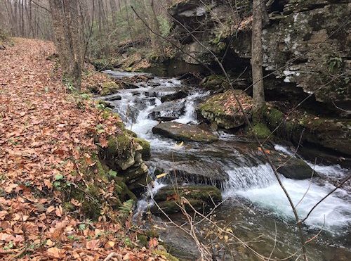
A mist enveloped Pine Creek valley as we headed north on Route 44 through a light rain—a touch daunting as the temperature was in the upper 30s. We were headed to one of the many small streams in the “Wilds” that perhaps one in a hundred area residents have even heard of—let alone hiked. We traveled through Waterville, soon crossing the creek and continued on 44 toward the Black Forest. About two miles past the bridge, we parked in a very narrow space along Upper Pine Bottom Run. A sign nearby announced the beginning the Ott Fork Trail.
Initially the trail follows Upper Pine Bottom Run but soon, at the confluence with Ott Fork it veered south, in a gradual climb along the “Ott”. Within a few hundred yards we reached a small falls spilling over a cliff and tumbling five or six feet into a small pool. There are small falls and twisting rock strewn rapids all along this magnificent small run.
The trail follows a very old road that crosses the run several times on old stone bridges —-except a scant half mile in where exceptionally heavy water must have washed the bridge out. We had to ford, using mid-stream rocks placed by earlier hikers. The water was up, the rocks less than stable, but we managed a dry crossing, continuing the very civilized ascent for about two miles reaching the intersection with Pine Hollow Trail.
Our plan for the hike was to access the ridge to the east, follow it north for a mile or more and hopefully intersect with WolfPath, which our map suggested would return us back down to Ott Fork. We began ascending Pine Hollow on a trail more serious about gaining altitude quickly, following a very small stream that wound through large Pines and Hemlocks. After a short, strenuous workout we reached the ridge, actually more of a plateau, and found Middle Hill Trail —which unfortunately had been turned into a gas industry road. Our sense of being in a spectacular, natural environment eroded.
We had some difficulty orienting ourselves on the plateau as the maps did not show all the gas industry roads or drill sites and we suspected that some of the trails were obliterated by them. But we did, after some discussion and a little help from GPS, agree on a direction likely to lead us to Wolf Path. Crossing a drill pad, we headed west and dropped off the pad into a dense laurel thicket, a density that made almost every step an effort. And Wolf Path was nowhere in sight. After battling the laurel for 20 minutes or more, we reached the edge of the plateau; the laurel thinned and we climbed down into a shallow but steep ravine. Wolf Path should have been parallel to the ravine but although we could imagine traces of an old road in places, nothing navigable appeared. We continued descending the ravine doing our best to keep on our feet through multiple steep fields of lose rock. Eventually we arrived back at Ott Fork—it was a good feeling.